Israel Military Control — Israel exercises direct military control over roughly 1,000 square kilometres of territory across the Gaza Strip, southern Lebanon, and southern Syria — a footprint that satellite imagery, geographic information system analysis, and conflict event data show has consistently exceeded officially declared boundaries.
The findings, drawn from an investigation using satellite imagery, GIS spatial calculations, and Armed Conflict Location and Event Data Project (ACLED) records, map Israeli military presence across three distinct theatres since the outbreak of hostilities on October 7, 2023.
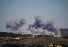
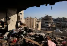
In Gaza, a ceasefire agreement signed on October 10, 2025 established a boundary known as the ‘Yellow Line’ — demarcated on the ground by yellow concrete markers — intended to define the limits of Israeli military control. Official Israeli maps placed that zone at approximately 200 square kilometres, yet analysis of the October 2025 agreement maps indicates the Yellow Line in practice covered roughly 53 percent of Gaza’s total area.
Recommended Reading
The markers themselves told a more expansive story. Physical yellow concrete barriers placed by Israeli forces up to early February 2026 were found in some locations to exceed official military boundaries by hundreds of metres. On November 20, Israeli forces advanced into eastern sections of Gaza City, pushing the markers approximately 300 metres westward and triggering the displacement of Palestinian families from the Shujayea and Tuffah neighbourhoods. Israeli military control in northern Gaza expanded from 67.3 square kilometres to 73.9 square kilometres — a 4.7 percent increase — during the period under review.
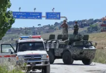
The situation in southern Lebanon followed a similar pattern. A ceasefire agreement between Israel and Lebanon was signed on April 17, 2026, with official maps published in its aftermath placing Israeli military control zones at approximately 570 square kilometres — more than half of all territory seized across the three fronts since October 7, 2023. Satellite imagery captured between April 24 and May 19, 2026 revealed that demolition operations extended beyond those declared lines into areas outside the announced boundaries. The town of Zawtar al-Sharqiyah in southern Lebanon showed significant destruction during that same window.
Southern Syria represents the third and most legally complex dimension of Israeli military expansion. The ‘Alpha Line’, established under a 1974 Disengagement Agreement between Israel and Syria, formally separates the occupied Golan Heights from the rest of Syrian territory. Israeli military positions now form a continuous strip running from Jabal al-Sheikh in the north to the Yarmouk River near the Jordanian border in the south, covering an estimated 235 square kilometres of permanent military infrastructure.
That presence is neither static nor confined to fixed installations. More than 800 documented Israeli military incursions into Syrian territory were recorded between December 8, 2024, and January 16, 2026. The deepest single penetration reached approximately 63 kilometres inside Syrian territory, near Horsh al-Jubailiya in the Deraa countryside, in April 2025 — well beyond any boundary recognised under international agreements.
Israel Military Control: Regional Implications
Taken together, the three zones illustrate a pattern in which formal ceasefire lines and official military maps have served as floors rather than ceilings for Israeli territorial control. Physical markers in Gaza moved westward after a ceasefire was in force; demolition in Lebanon proceeded past declared boundaries; and incursions into Syria ranged across a broad operational envelope rather than adhering to fixed positions.
The investigation underscores the gap between the cartographic boundaries presented in diplomatic agreements and the ground-level reality documented through independent satellite analysis — a discrepancy with direct consequences for the hundreds of thousands of civilians living in proximity to those shifting lines.